AI drone for the Cities
As we wrote earlier, digitalisation and AI is key to reduce money, time and energy overspending.
In this article I would like to describe several cases how drone and AI methods of image and video processing can significantly improve Urban analysis and planning.
Digital twin of the city
Digital twins are already transforming manufacturing processes and industrial design. But not only that. You can create a digital twin of an entire city, making urban decision-making much more accurate and faster. Here, for example, is Singapore's complete digital twin.
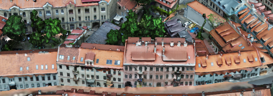
We started to make a 3d model of Vilnius with Uzupis district to begin with. You can check how informative 3d models can be.
Creating such a digital twin is a rather time-consuming and labor-intensive work.
Fortunately, much easier and cheaper applications for AI and Drones are exist too.
Roof monitoring
Damage identification and Restoration
Modern buildings usually have full documentation.
Historic buildings that need to be restored do not have an exact schematic. Documenting and understanding the amount of work required takes the time and resources of workers.
Using drone and special software can help to get the scheme of the building fast and cheap.
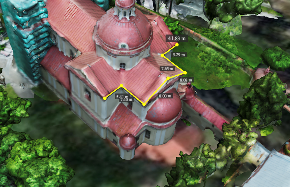
Moreover AI recognition of roofs, objects (such as chimneys), defects and damages can significantly save and speed up the work. And of course it is much safer.
Insolation
Now that the installation of solar panels is becoming a steady trend, the automatic calculation of insolation will be a significant argument in favor of the use of drones for this purpose.
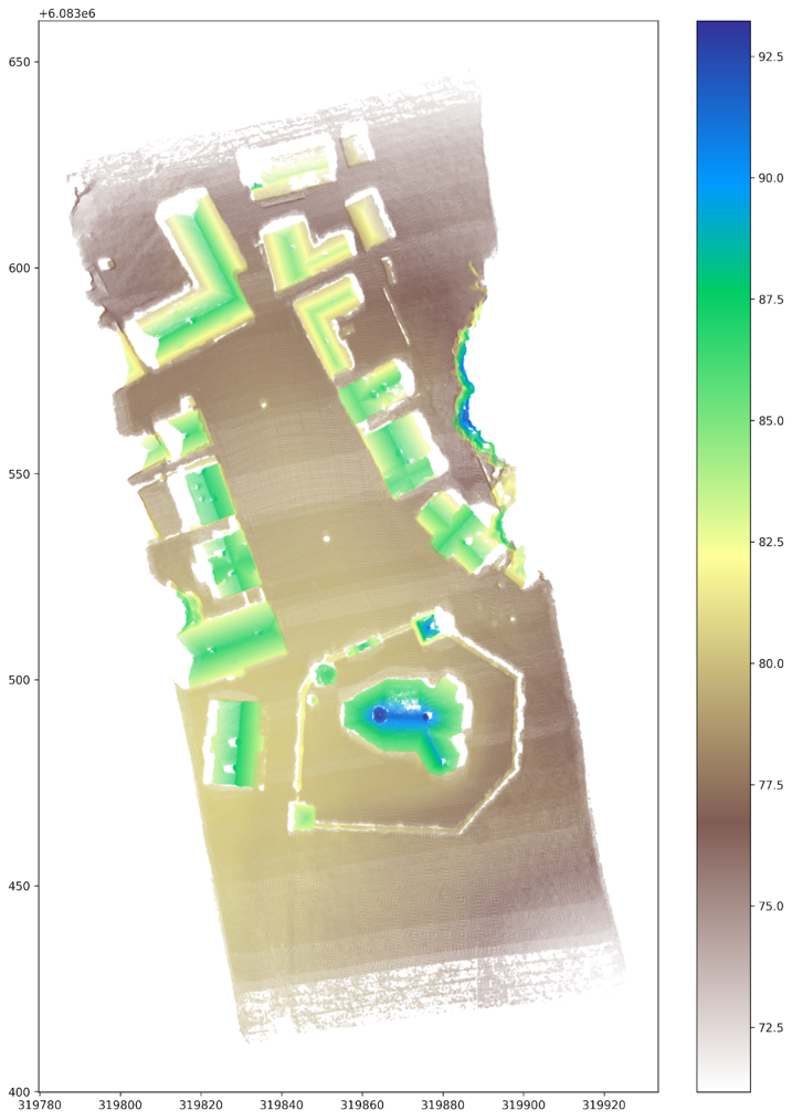
Knowing the roof angles, roof’s area and height of objects that can shadow the roof allows us to calculate how much the house holder will save energy by installing solar panels.
The color scale indicates the altitude above sea level. You can see that the accuracy of the map allows you to calculate the angles of the roofs and their area.
Over time, solar panels become dirty, which reduces their efficiency. AI processing of UAV images can automatically detect dirty or damaged panels on rooftops.
Thermal imager
By adding a thermal imaging camera to the drone, it becomes possible to search for heat leaks. Moreover, it is possible to calculate the heat output of an entire building in order to decide whether to insulate the building to reduce energy consumption.
Trees monitoring
Another useful application of AI drones is the detection of trees and their heights.
This can be effective for forestry as well as for city planning.
We have previously done an analysis of the degree of greenening in Vilnius and Kaunas.
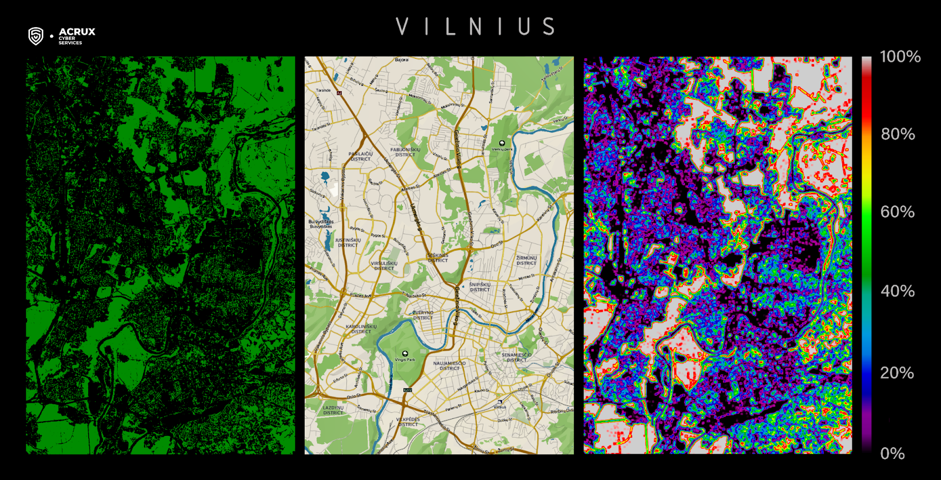
As you can see, the real data is significantly different from the data from google maps. And taking into account the heights of trees, the analytics can be significantly deeper.
Identifying dry trees that can be hazardous to people and infrastructure is important to save lives.
For example, in one of our projects we monitored the safety of power lines with UAV several times faster and cheaper than before.
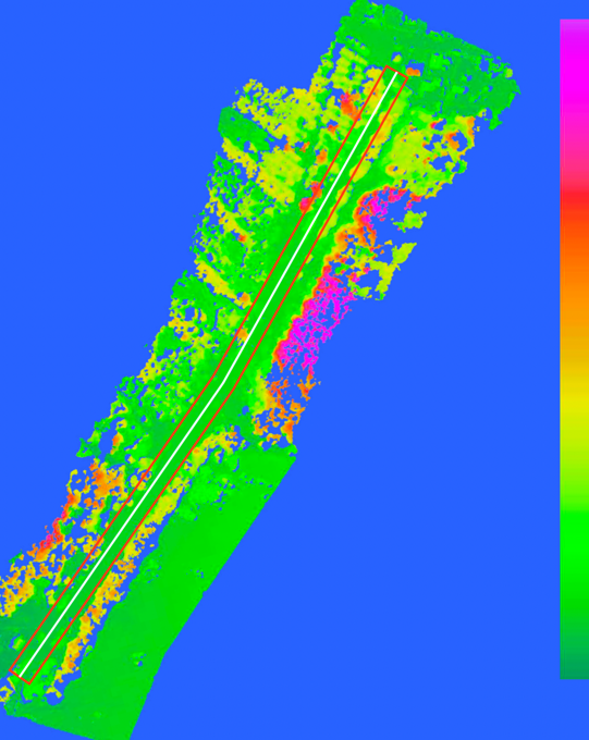
White line - power line, red lines - right-of-way, other colors - elevation map. Error of measurements is less than 5%.
Classification of objects
Automatic object classification can save many man-hours in image processing.
The AI can identify garbage dumps, damage to the roadway or lawns. You can identify paths that are trampled over lawns to make a walkway there.
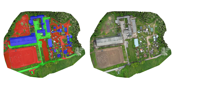
marked area plan
In red - land and paths
Blue - roofs of buildings
Green - asphalt
In this short article, we looked at some ways to apply AI processing to photos from an amateur drone.
Of course, there are many more uses for this technology.
If you have similar challenges, write to us and together we'll come up with the best solution for you to reduce costs and improve profit, safety, and measurement accuracy.
Anton Balakirev
Chief Technical Officer
Acrux Cyber Services

